What to Know About Drones in Agriculture
When it comes to drone capability, strength, and speed, professional drones are top of the line. Manufacturers design these machines to appeal to industries where they would not only be convenient but necessary. From the film industry to survey farmers, professionals know how to put these drones to work. As technology advances, drones become more and more capable.
Professional drones are generally higher quality than the toy drones enthusiasts use for recreation. Manufacturers build these hardier and with extra features that are suited for agriculture, film, utility companies, and more. As drones gain in popularity, the businesses that have something to gain from them also grow in number.
There is one business, however, where you’ll see drones soaring high! Here is what you need to know about drones and the agriculture business.
Drone Use in Agriculture
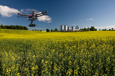
When it comes to agriculture, drones have found a natural place in the business. Farmers cannot be everywhere at once. However, with a drone, they are able to survey their land with real-time information. Farming involves keeping track of many different components. From crop health, water use, and soil analysis, farmers have a lot to keep track of. In the past, before drones were a major asset to farming, people invested in plane surveillance. Planes can’t be used as often and with the expense of manned aircraft, farmers tend to use data surveillance by plane sparingly. Drones, on the other hand, can survey the land on a daily or weekly basis.
When used, these drones can complete a variety of jobs on farms and ranches. Here are just some of the tasks that they are capable of:
- Diagnosing problems with plants
- Imaging that can determine water efficiency
- Imaging for soil erosion predictions
- Imaging of pest infestations
- Crop dusting
One interesting fact to keep note of is that you can use a drone with a near-infrared sensor to determine stress in plants. Plants can show signs that they are in distress before you’ll see any signs of physical damage. This gives you an upper hand and the ability to try to save your plants before any permanent damage occurs. Additionally, farmers may use the sensors to identify soil damage or erosion. When you have problems with your land or crops, it’s important to know about them in advance so that you can plan further ahead.
When you have the time to make a plan, then you have a chance to save your crops and maximize your productivity. Drones make it possible for you to gather extra information in a fast and convenient way. Your eyes aren’t going to be able to tell you when a plant is in distress or when there’s unseen soil damage. Drones are fast, convenient and highly effective.
Take for example how the agricultural industry uses thermal imagining to determine whether a farm is watered adequately. Keep in mind that watered areas tend to be cooler than the areas that are not. A great drone to use for this purpose is the DJI Inspire 1. Not only is it fitted with thermal imagining but it also has 3D mapping and crop monitoring capabilities.
Fixed Wing Drones
Fixed-wing drones are preferred by the agricultural industry. This is because their batteries tend to last longer and they can survey larger expanses of land. This is better in terms of surveillance and data collection over a large area. Fixed-wing drones fly higher and spend more time in the air than multi-rotor drones. Since these are also larger and can carry more, they are often equipped with more sensors. This allows ranchers and farmers to get more work done. When it comes to this type of drone, they tend to look more like airplanes with large wingspans.
Here are two common fixed-wing commercial drones for agriculture:
PrecisionHawk Lancaster 5
With high stability, the Lancaster 5 is a sturdy fixed-wing drone. Onboard, it has sensors that can measure temperature, air pressure, and humidity. It can also respond to changing weather conditions. With an inflight monitoring system, you can monitor its battery life, altitude, and position from home. It is also capable of 2D and 3D mapping.
Drone Features:
- 45 minute flight time
- 4.9 FT wingspan
- 300 acres survey area per flight
- 12-16 m/s cruise speed
- 5.3 LBS
Sensefly eBee SQ
The Sensefly eBee SQ is practical for data collection. In one flight, you can capture the soil temperature, H20 levels, and plant counts. Additionally, it is capable of 3D mapping.
Drone Features:
- 55 minute flight time
- 110 cm wingspan
- 500-acre survey area per flight
- 28 mph cruise speed
- 2.4 LBs
Multi-Rotor Drones
Multi-Rotor drones are also a good choice for farmers, especially when you want a drone with more control. These drones have more than two rotors for flying. This can be especially helpful for beginners. Now, when you want to fly your drone low to the ground or need it to fit into smaller places, the multi-rotor is more advantageous. For many farmers, the type of drone that you choose depends on the size of your farm and your level of skill with a drone.
Here are two common multi-rotor drones:
DJI Phantom 4 PRO
This is an easy-to-use beginner agricultural drone. With Sentera’s NSVI upgrade, it is capable of capturing high-resolution color. This is a great way for a farmer to determine the health of their land. Predominately used for scouting, it is a hardy agricultural drone.
Drone Features:
- 30 minute flight time
- 4.3-mile transmission distance
- 45 mph cruise speed
- 2.94 LBs
SOLO AGCO Edition UAV
This drone contains high-resolution mapping software that farmers can utilize on their properties. With two cameras, aerial mapping is not only possible but is also easy to carry out. This is a great drone for those who need to scout.
Drone Features:
- 20 minute flight time
- 55 mph cruise speed
- 2 customized cameras
- Automatic takeoff
When you purchase a drone, it can come with many different features and add-ons for the specific tasks you need. If you need a higher resolution camera or specific imaging, it’s possible to customize your drone to fit your needs.
Animal Agriculture
Many farmers and ranchers have an extensive amount of property in which large herds of animals can roam. In this case, it may be difficult for farmers or their work animals to monitor the herd at all times. Drones are lightweight, fast, and can follow herds wherever they roam. Not only do they have a live tracking system, but also professional, commercial drones for agriculture can feed live video to your laptop or smartphone.
In addition, a drone equipped with infrared or night vision will be able to see your animals even when you can’t. Cows, for instance, have a tendency to hide in forested areas, under the canopies of trees. With the right infrared technology, you’ll be able to see them through the trees when you might not have been able to find them yourself. It won’t be long before drones are a staple of animal agriculture. These devices can be used to raise and manage livestock. In fact, if you need a solid herding tool, drones can perform that too.
While they continue to develop and better the technology, there is a future for drones in agriculture, especially when it comes to working with the animals themselves.
What Makes Drones Better?
New technology can be daunting. Despite having been on the market since the 90s, drones have only started gaining real popularity in the last several years. Don’t be like some people in the industry, however, and be too nervous to take that leap! It’s worth it in the long run and we can tell you why.
First, consider the price. Using other aerial methods can cost a lot of money. From manned aircraft to satellites, you are paying too much for aerial pictures. Drones cost less money; their imaging is by far cheaper. Second, they have offered more precision when it comes to picture taking. Why spend extra money on images that won’t turn out as well? Here are a few other benefits to drones:
• Detects pests and other problems quicker due to frequent surveying
• Can scout the entirety of a field
• Images can be used to calculate the size of hills and holes.
Commercial drones for agriculture will continue to gain in popularity. For one farmer or an entire team to keep track of plant and animal health can be exhausting and in some cases a losing battle. People can only do so much. Many farmers end up surveying the perimeter of their land, rather than being able to visualize every part of it. Even if you could, it would not be something that you could take part in every day. Drones offer more of a guarantee. They are an investment that can change the face of agriculture and save money in the end. These drones could be yours and all you have to do is make sure you have the battery life.
From simple images, 3D mapping, to infrared technology, the drone has few tasks unfit for it.